Sunday, 29 April 2012
Love walking, love beef, hate cows
Now cows have a reputation for being fairly docile creatures who stand around all day chewing the cud and basically doing very little else apart from leaving very large 'pats' for the unwary traveller to step into. I know better though. You see I seem to have had problems with cows going all the way back to childhood. Indeed it was an incident on a school trip, when a cow took umbrage to the fact that I'd stroked it, that I gained my first nickname - Mattmoo. Since then I've always been wary of cows but it was not until I took up walking as a hobby that I've been forced into regular contact with them, often with scary results.
For example, last August I was walking back to Renwick towards the end of a superb walk on to Black Fell in the North Pennines when I was confronted with a field with some cows in it. Now because of my bovinephobia I stood a while contemplating going the long way round via a road. In the end I decided to 'man up' and face my fear, though I still tried crossing the field whilst staying as far away from them as possible and with my eyes averted in order to cause the least offence. I got to within 15 metres of the gate on the far side when they just started to run towards me. I certainly wasn't going to wait and ask them what they wanted so legged it to the gate which I then hit at high speed, flipping me over and landing me on my back on the far side. Thankfully there was no one around to have seen my spectacular vault over the gate nor the subsequent hand gestures I made at the vicious brutes once I realised I was safe. It was more than my pride that was bruised though, I had a sore shoulder for a week and a bruise up the whole of my right shin which lasted about a month.
Young cows and calves are a particular problem. Whilst a lot of cows are admittedly just as nervous of me as I am of them the youngsters have, to me, a rather unhealthy streak of curiosity. I remember one time in 2005 when returning from a fine tramp in the upper reaches of Colsterdale and Nidderdale I was crossing a field full of cows and calves. A small group of calves decided to check me out so the mummy cows followed to keep an eye on them. Within seconds I had cows heading towards me from all directions so I clambered up on to the nearest drystone wall for safety only for all the cows in the next field to come and check me out as well. I stood on that wall for almost 5 minutes completely surrounded before I plucked up the courage to jump off and make a dash to the nearest gate and safety (fortunately I got over this particular gate without any mishaps). On a more recent occassion I can remember being tracked by a young cow, which kept calling back to the rest of the herd, for over 400m across open fellside before it eventually gave up and left me alone.
I've had numerous other incidents over the last few years and just a couple of days ago my mere presence seems to have a sent a gang of bullocks in to a frenzy as they charged up and down alongside the rather flimsy looking fence desperately trying to get to me on the adjacent path. Given the rather dubious protection of said flimsy fence I climbed over into the next field for extra protection. Strangely enough though I've not really had too many problems with bulls. I've seen plenty of 'Bull in field' signs but most of the time said bull was nowhere to be seen (in fact they are almost never seen which makes crossing a field with such a sign all the more nervewracking just in case the local bull is equipped with some kind of invisibility cloak).
The one time I came close to a bull without the protection of a wall was, rather bizarrely, on the summit of Fellbarrow in the Lake District. It was stood just yards away from the trig point. I'm still rather proud that I plucked up the courage to go up to the trig point and take some photos but to be truthful the bull barely moved, it seemed to be too engrossed in the view across the Vale of Lorton to the North-Western fells to have any interest in me, and to be honest who can blame him. It should also be said that I've had very little problems with 'hairy' breeds of cattle such as the Galloway, Belted Galloway or Highland cows, all of which can today be found on the high limestone pastures of the Dales, particularly around Malham and in parts of Ribblesdale.
Other than the omnipresent fear of getting trampled by rampaging cows (and lest anyone think I am being over the top it does sadly happen to unfortunate walkers) there is another reason to dislike cows. Farms, often not the most fragrant of places anyway, are usually much worse for the presence of cows. I hate it when I have to cross a muddy farmyard especially when you just know that the 'mud' you are squelching across is an unholy mixture that is at least two parts cow dung and urine. Cows also have a tendency to trample wet ground into a quagmire which makes even crossing a field they have vacated a rather messy experience.
If given the choice I'd prefer to avoid farmyards altogether and it would make me happy if I never had to walk through another field of cows again. Unfortunately this just isn't practical. If I want to continue exploring our glorious countryside I'm just going to have to find a solution to my dislike and fear of bovine kind. Perhaps I could ask one of those bulls if I could borrow his invisibility cloak.
Friday, 23 December 2011
Walk Review 2011
For a start I managed to complete most of the walks I'd planned out for the year and in doing so also managed to visit a fairly good variety of areas. Perhaps the two areas that most stood out for me in 2011 were the North Pennines and the Lake District. Between the beginning of February and the end of May I did half a dozen walks in the North Pennines which together greatly enhanced my appreciation for what is a greatly underrated and often ignored area for hill walking. After 7 North Pennine walks in total in 2011 I now only have a few North Pennine 2000ft tops to visit. More importantly I finally got round to climbing Mickle Fell, the historic top of Yorkshire, but which has awkward access issues due to its location on the Warcop Range.
Another important walk for me was when, in March, I climbed Whiteside, Hopegill Head and Grasmoor in the North Western Fells of the Lake District. This was my first walk in the Lakes since June 2009 when, at the time, I had been struggling with a knee problem which subsequently turned out to be torn cartilege. Having been an avid Wainwright bagger prior to that injury it was great to get back into the swing of things. In total I bagged 14 new Wainwrights in 2011 and have just 17 more to go to complete the whole set.
It was on one Wainwright bagging expedition that I also managed my first wild camp. Wild camping was one of those things I just knew would add a new dimension to my love for the hills but had never got round to it. Finally in July, with my friend Matt, I camped out by Sprinkling Tarn on Seathwaite Fell. Later on, in September, we also wild camped on Swarth Fell in the Yorkshire Dales. Despite the lack of sunsets and sunrises I thoroughly enjoyed both expeditions and hope to do a lot more in the future.
In my review of 2010 I mentioned the fact that I felt that I'd been fairly lucky with the weather. Looking back over the last 12 months I'm unable to give such an upbeat assessment. Perhaps I was just unlucky but, certainly for the first six months of the year, an excess of cloud and a lack of good visibility characterised the weather on many of my walks.
Frustratingly, even when we had the extended dry spells in March and April when it was sunny it was also very hazy so visibility was poor. On one occassion it so hazy that I could barely make out Derwent Water from Skiddaw Little Man despite there not being a cloud in the sky. It wasn't until my 11th walk of the year in mid-March that I was able to enjoy the dual combination of blue skies and good visibility.
Another element of the weather that has characterised the last 12 months has been the frequency of fairly strong winds. Now anyone who spends any time walking in the hills will expect it to be windy but it seems to have been especially so this year, particularly in April and May, although some of the strongest winds I've been out in were on the Win Hill walk I did in the Peak District in November.
Anyway the following, in no particular order, are my best and worst moments on the hills in 2011. The following are highly subjective and as with all walking experiences were very much dependent on conditions overhead and underfoot.
Top 5 walks
1. Cnicht (Snowdonia)
2. North Kinder Edges (Peak District)
3. Great Hetha and White Law (Cheviots)
4. Cold Fell (North Pennines)
5. High Raise and Rampsgill Head (Lake District)
Top 5 views
1. View from White Law on the Border Ridge in the Cheviots.
2. View of Nantgwynant valley from Moel Hebog.
3. Autumn sunshine on the eastern edges and Ladybower from Crook Hill.
4. The Howgill Fells from West Baugh Fell.
5. Buttermere Valley from Mellbreak.
Top 5 moments
1. Discovering the patch of rare Spring Gentian on Mickle Fell.
2. Getting to the top of Whiteside, my first Wainwright in nearly 2 years.
3. Enjoying the bluebells in Littledale, Forest of Bowland.
4. Descending into Whitendale, Bowland, from the Salter Road.
5. My first experience of wild camping.
5 Worst Moments
1. Being chased out of a field by a herd of cows near Renwick in the North Pennines.
2. The detour on to Soil Hill in the South Pennines, despite the numerous public paths on the map the locals clearly didn't want walkers around and to top it off the summit was a huge spoil tip.
3. Getting the wobbles near the top of the north east buttress of Lonscale Fell, I've managed Striding Edge and Sharp Edge no problem but this route definitely got my adrenalin flowing.
4. After nearly a whole day of poor visibility and wintry conditions the last few miles of an epic walk over Grey Nag and Black Fell in the North Pennines were mentally very taxing - good recovery later on in The Angel in Alston mind!
5. Ripping my trousers from knee to crotch while leaping an innocuous stream on Barden Moor.
Overall it has been another cracking year for walking but now my thoughts are already turning to where I'm going to go next year. Roll on 2012!!!
Happy Christmas.
Matt
Friday, 7 October 2011
Walking the Border
My first visit to the so-called Border Ridge was back in 2005 when my wife, Lisa, and I went on a camping trip to Kielder. After spending a suffocating night in a midgie infested tent we set off on what proved to be a grand walk over Deadwater Fell and on to Peel Fell which is neatly dissected from south-west to north-east by the border. Here the dividing line between England and Scotland is marked by a line of widely spaced wooden stakes. Without a wall or fence to hinder me I was able to take a child-like delight in literally walking along the border with one foot in England and the other in Scotland.

I’ve since revisited the Border Ridge several times and climbed some of its major summits, including Windy Gyle and The Schil. For much of the way the border is marked by a fence which is shadowed for most of its length by the Pennine Way. The views, both into England and into Scotland are superb and I’d rate the panorama from Windy Gyle as one of the finest in the country. Recently I enjoyed superb visibility from White Law at the northern end of the Border Ridge. Looking into Scotland I could see beyond the distinctive profile of the Eildon Hills to Broad Law, the second highest fell of the Southern Uplands over 40 miles away.
It is not just the colourful hills, the outstanding views, or the thrill of being able to cross at will from England to Scotland that makes the Border Ridge such a special place for walking. Located so far from any major urban centres the Cheviots are anything but overcrowded. Their wild beauty and remote solitude make the area a paradise for walkers. There is also a lot of history as well. Bronze Age burial cairns, Iron Age hillforts and Roman camps can all be found on or near the Border Ridge.
Though quiet and peaceful today it is also an area that has seen plenty of conflict. From the wars between the kingdoms of England and Scotland in medieval times to the raids of the Border Reivers in the years before and after the Union of the Crowns in 1603 the Border Ridge and the surrounding hills has seen plenty of strife. The results of the endless raids, murders, skirmishes and battles all helped form the border as it is today.
George MacDonald Fraser, author of the ‘Flashman’ series of novels and historian of the Border Reivers described the Cheviots as, ‘the most romantic hills in the world’. Whilst I have not travelled enough to dare to agree with that epithet I’d certainly argue they are among the most beautiful and the Border Ridge itself is certainly one of my personal favourite walking areas.
Monday, 3 October 2011
Book Review: The UK’s County Tops, Jonny Muir, Cicerone (2011)
So I was excited and intrigued when I was given the opportunity to review Cicerone’s latest walking guide, ‘The UK’s County Tops’ by Jonny Muir. I’ve been aware of the County Tops list for a while but my ambitions in this area have been restricted to the ones within the Pennine range. Rather than being based on the modern system of counties and unitary authorities, this book is based on the “historic counties”, i.e. counties that existed before changes to local government boundaries in 1974. That makes 91 historical county tops; 39 in England, 33 in Scotland, 13 in Wales and 6 in Northern Ireland. The county tops range in height from the 1344m high Ben Nevis in Inverness-shire, to the aptly named, 80m-high Boring Field in Huntingdonshire.
The author Jonny Muir is well placed to write this guide, having become the first person to visit all 91 county tops as part of a single 5,000 mile walking and cycling adventure in 2006. It took him more than three months to complete – a remarkable achievement.
The book is well laid out, divided into four sections that cover the county tops of England, Wales, Scotland and Northern Ireland. A short introduction to each county top is given, with a recommended route, a plan of the route using OS 1:50,000 scale mapping, and a ‘Did You Know’ section which provides a ‘Famous Native’ and ‘Interesting Fact’ for each county. Some county tops are so close to each other they can be visited in the same walk.
As the author says in his introduction, “No other hill list is quite like this one. No other is as diverse or, frankly, as wonderfully ridiculous”. The list is certainly diverse and admittedly there is something ridiculous about some of the county tops, particularly some of the ones in southern England, like the aforementioned Boring Field. Perhaps the nadir is Betsom’s Hill, the county top of Kent, which is actually inaccessible as it lies in somebody’s garden! On the other hand, for those of us, like me, who live south of the border and feel daunted by the list of Munros, the Scottish County Tops provide a doable list of hills to climb in Scotland.
The book has undoubtedly opened my eyes to the potential of the County Tops as a viable hill list, and would prove indispensable if, god forbid, I ever found myself at a loose end in the Home Counties. In particular, it’s reinforced my desire to get myself over to Northern Ireland for some serious hill walking at some point.
I do, however, have some problems with the book or, more specifically, the walking routes that Muir provides. Roughly three quarters of them are of the ‘there and back’ variety, usually starting from the nearest point of access from a road. This is fine if the purpose it to get to the summit and back again in the shortest available time, but as this is supposed to be a walking guide, it would have been a lot better if more interesting routes were provided. I was particularly irked by the walking routes that Muir provides for The Cheviot and Hangingstone Hill. The latter is the highest point in Scotland’s Roxburghshire, but in reality it’s merely a shoulder of The Cheviot (county top of Northumberland). Muir provides separate routes, “for the sake of preserving national identities” but rather bizarrely starts both walks from Langleeford in the Harthope Valley. Not only that, they’re both ‘there and back’ walks when the two could easily be combined to produce a more satisfactory circular walk. Besides if Muir really wanted to preserve the national identity of Hangingstone Hill surely he should have provided a route starting in Scotland, perhaps from Cocklawfoot, for example. This is just one example; I could provide a lot more.
Another disappointment was the length of some of the walks. In fact ‘walk’ is something of a misnomer as some of them are no more than a 30 minute stroll from the car. Even given that this is all that is feasible for some of the English county tops I do feel more effort could have been made to give more extended and interesting walking routes. Just because you can park right next to the summit of Dunstable Downs, the highest point of Bedfordshire, doesn’t mean you should, especially when there’s a nearby chalk escarpment to explore. In complete contrast Muir’s route for Scafell Pike, which starts from Great Langdale, climbs both Bow Fell and Esk Pike before heading over Great End to Scafell Pike – a very challenging and somewhat circuitous route!
For pure, unadulterated peak baggers I would wholeheartedly recommend this book. For anyone who is genuinely interested in completing the UK county tops it is, of course, definitely worth checking out too. The book has certainly piqued my interest in the county tops but I’d be more likely to use it as a reference than a walking guide. There are some fantastic looking hills to visit contained within these pages, just not in the manner described in the book.
'The UK's County Tops' is available to buy from the Cicerone website.
Wednesday, 7 September 2011
A Surfeit of Summits
In total there were 11 summits to visit - on paper it looked like a peak bagger’s wet dream. The reality was somewhat different. Well before I reached the final summit of the walk it was clear that I was experiencing a condition previously unknown to me – summit fatigue, or, to put it another way, I was suffering from a surfeit of summits.
I’ve read some critical comments from people who complain that most of the summits on the Glaramara ridge are no more than minor bumps and are of little interest. I disagree. Yes some of them are, relatively speaking, fairly insignificant but in my experience every single one of them was worth visiting.
Allen Crags was the highest, Glaramara the grandest. Looking Steads had the best view south and Combe Head had the best view north whilst Rosthwaite Cam featured an enjoyable scramble to reach the highest point. However, of all the summits visited, it was the area of delectable tarns around the small knoll known as High House Tarn top that was perhaps the most beautiful.
It wasn’t the quality of the summits on offer that was the problem it was the quantity. The walk was an endless succession of ups and downs with few flat areas to provide any respite for the knees. Instead of getting into a stride we were halting every half mile or so to take photos as we bagged another top. It all began to get just a bit tedious and (I never thought I’d say this) boring.
Bessyboot was the final summit of the day. The steep climb up from Tarn at Leaves proved to be a real sting in the tail. By the time the top was reached it had taken four and a half hours to travel the three and a half miles from Allen Crags. I can’t remember a walk where my pace has been so slow (though in my defence it has to be pointed out that I was carrying a heavier than usual pack having camped at Sprinkling Tarn the night before).
In the future I think I’ll have to try and make sure I don’t visit too many summits in one walk (there goes some of my walking plans for peak bagging in Wales). As for the Glaramara ridge I would definitely go back but I think instead of taking it all in one go I’ll do it in bite size chunks to allow me to savour it more.
For hill-bagging geeks who are in to this kind of thing I bagged 9 Nuttalls, 4 Hewitts, 3 Wainwrights and 1 Dewey. While you try and work out how all those added together adds up to 11 summits I think I’ll go in search of some bourbons.
Monday, 8 August 2011
Going wild at last
Whilst the initial walk up to Sprinkling Tarn from Seathwaite and the following day's peak bagging fest on the Allen Crags - Glaramara ridge can be viewed on the main mypennines website I thought I'd take the opportunity to blog about both my reasons for wanting to go wild camping and how I found my first attempt.
I should perhaps point out first that I'm not a complete novice at camping. Back in 2005, when I first began to consider buying a backpacking tent, I opted instead to purchase a 3 berth tunnel tent for Lisa and I to use for weekends away. We used this tent on numerous occasions over the next two years for weekend breaks visiting the North Pennines, Hadrian's Wall country, Kielder, the Ogwen Valley in Snowdonia, the Northumberland Coast as well as the first of a number of trips to the Lake District.
Whilst I had thoroughly enjoyed all those trips (though the midgies at Kielder were a nightmare!), and especially the liberty it gave us to explore new places, I have always still wanted to try out a wild camp. The main reason for this is quite simple - I love the hills and mountains of this country and, more specifically, I love being high up in the hills. As something that would allow me to spend even more time on the hills then wild camping was something that I just had to try sooner rather than later. The opportunity to enjoy seeing the sun come up and go down from a high vantage point was of particular appeal to me.
In January of this year I finally took the plunge and purchased a backpacking tent along with a new, lighter, sleeping bag and a few other necessary accoutrements. Earlier, for Christmas, Matt had already bought me a Spork and a trowel ...
Having all the necessary equipment it was then a case of waiting for the days to grow longer and for a time when both Matt and I would be available for a whole weekend. Our trip was first scheduled for the middle of June but just the day before I cancelled, the forecast for that weekend being heavy rain and gale force winds neither of which I particularly wanted to experience on my first wild camp, especially in the 'wettest place in England'.
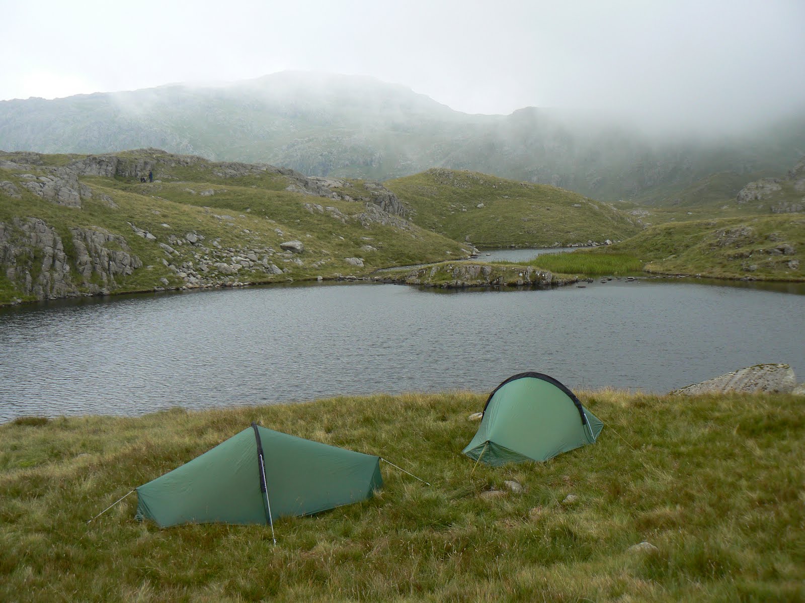
So it was that last Saturday I finally got to pitch my tent by Sprinkling Tarn. So how was it? We arrived at Sprinkling Tarn just as the light was beginning to fade and we soon both donned our head torches as we pitched our tents. I'd only had one practice attempt at putting the tent up (on my front lawn) so thankfully it was easy enough to manage 'out in the field'. I was also a bit concerned that, given the popularity of Sprinkling Tarn as a wild camping location, that there would be loads of people up there and it wouldn't feel very wild at all. I needn't have worried, while there were a few other tents dotted about none were visible from where we pitched and to all intents and purposes might not have been there.
Wednesday, 20 July 2011
The Gentle Art of Fence Following - Peak bagging in the North Pennines
One of the reasons for this is that, with the exception of the summits that are visited by the course of the Pennine Way (Knock Fell, Great Dun Fell, Little Dun Fell and Cross Fell), none of the other 29 tops can be visited by using a public right of way. A few, such as The Dodd and Great Stony Hill are close enough to a right of a way to require only a short detour but the majority stand well away from well trodden paths and before the CRoW Act would have been seen by most walkers as being quite out of bounds.
Whilst the CRoW Act has now made it permissible to visit these summits there is still the issue of what route to take, a problem exacerbated by the fact that, without the benefit of a well trodden right of way, walkers are faced with crossing miles of tussocky grass, deep heather and substantial areas of peat hags and groughs. All of this adds up to, in my opinion, some of the roughest walking conditions in the country.
While the high places of the North Pennines may be lacking in useful paths or bridleways they certainly do not lack in walls and fences. It is these walls and fences that often provide the key to navigation, especially in poor visibility, where they act as both a collecting feature as well as being a useful hand rail to follow. In fact in many areas of the North Pennines boundary fences are often the only visible feature of note.
I've done half a dozen walks in the North Pennines this year and, in addition to the ones I'd already been to, I have visited another 13 'Nuttall' tops (I only have 4 left to do now). A recurring theme of these walks has been the miles upon miles of fence that I've followed. Furthermore many of the summits I've visited have lain within a few yards of a fence. Fences have become an almost constant companion and on at least two occassions this year I must have shadowed about 10 miles of fence in a single walk.
As mentioned there are very few paths that visit the higher summits in the North Pennines. Since fences are often the only navigational guide available a slim trod, created by walkers, will sometimes develop alongside a fence. More often than not though the only sign of anyone else having passed by is the occassional sighting of a boot mark in the peat. Of course sometimes it can get tedious. In poor visibility, when all you've seen for several hours is a frost lined fence and the frozen peat below you're feet then you do yearn for something different.
So far I've not really done a very good job of promoting the North Pennines as a good area to go walking. Certainly it would not be to everyone's taste. However, at a time when areas like the Lake District are becoming increasingly overcrowded the North Pennines offers sanctuary for those who perhaps treasure peace and solitude over excitement. Recently I saw more people on the small summit area of Kidsty Pike (hardly the most popular Lake District mountain) than I have seen in over 60 miles of walking in the North Pennines this year.
Indeed it is the very fact that it is so rare to actually come across another walker that the North Pennines has so much appeal to me. There are of course lots of other reasons why I enjoy walking there; the bird life, interesting flora, the wide ranging views and the general feeling of remoteness are just a few of them. On the other hand I wouldn't want to encourage too many people to go therer, I'd rather it stayed the way it is. I have three more Nuttalls to tick off from my 'to do' list. After that I'll move on to complete the remaining Dewey tops (summits over 500m) that I've not yet visited. I still have many more miles of fence following to look forward to.